Abandoned Colorado ghost towns that will give you the chills
In 1858, prospectors struck gold on Cherry Creek, and in an instant a generation of Americans and fortune seekers from abroad was bound for what would become Colorado. It worked out OK for Denver, which became the largest and most influential city in the Rockies. Thousands of other towns in Colorado weren’t so fortunate.
From 1858 until the silver crash of 1893, towns popped up almost overnight where gold or silver was found. Just as quickly, the vast majority were abandoned when the ore ran out, often in places so difficult to reach even today that you’ll wonder how the miners managed daily life.
Most of these hamlets are gone, but the mountains are littered with their crumbling remains – cabins, bunkhouses, stores and mining structures. They stand as a testament to the pioneers’ ingenuity and monuments to their often-broken dreams.
Visiting these places is akin to stepping back in time. Some you can reach on dirt roads passable in the family sedan. Others require a four-wheel-drive vehicle. Still others remain deep in the wilderness, reachable by lacing up a pair of sturdy hiking boots. Each has its own unique story of success and then failure.

This is your guide to touring some of Colorado’s best-preserved ghost towns. Keep in mind that old mines are dangerous and can be home to explosive or poisonous gases. People have died falling into shafts, so explore with care and don’t get too close.
Bachelor Loop, Creede
The last great mining boom in Colorado was centered in the San Juan Mountains. Silver was struck here in 1890, and within two years there were dozens of mines and boom towns around what is today the town of Creede. The frenzy of activity was short-lived. In 1893 the Sherman Silver Purchase Act was repealed to resolidify the gold standard; the federal government stopped buying silver and the mines collapsed.
Unlike many of Colorado’s old mining towns, Creede itself is still there, a tourist hotspot. The Creede Repertory Theatre draws enthusiasts from across the country each summer. You can drive the scenic 17-mile Bachelor Loop above town and take a trip past some of the best-preserved mine sites in Colorado. There are several interpretive signs and stops of interest. Those with four-wheel-drive can take side roads deeper into the terrain. Cyclists are encouraged to take the loop counter-clockwise, tackling most of the climbing in the first 4 miles.

Crystal Mill
This picturesque old mill, perched on the side of a waterfall, is one of the most Instagrammed spots in Colorado. The mill was built in 1893 to support the Sheep Mountain Tunnel mine near the present town of Marble. It generated compressed air that powered tools used by the miners. The mine limped on until 1917 when it closed. A few people still spend summers in cabins in the nearby hamlet of Crystal, once home to about 500 people.
You need a sturdy vehicle – preferably four-wheel-drive or off-highway – to get to the mill from Marble. Otherwise it’s a 4-mile hike each way along the road. The site’s beauty is worth every step. Heed all signs marking private property. (Note: It costs $10 to access the private property from which some of the most iconic photos are taken.)

Ghost Town Hollow
You’ll need a pair of hiking shoes to reach the remnants of this settlement at about 11,800 feet elevation on Pikes Peak. The cabin foundations and old boilers are all that remain of an effort to blast a tunnel into the heart of the mountain in search of valuable metals. A fatal explosion terminated the endeavor, and the mine entrance was sealed about a dozen years ago to keep people out.
To get there drive the Pikes Peak Highway ($5-$15 per person age 6 or older; discounts per carload) to mile marker 14 and park at the Elk Park trailhead. It’s an easy 1.4-mile downhill hike to an intersection. Turn right at the sign for the Oil Creek Tunnel and it’s a half-mile uphill to the ghost town.
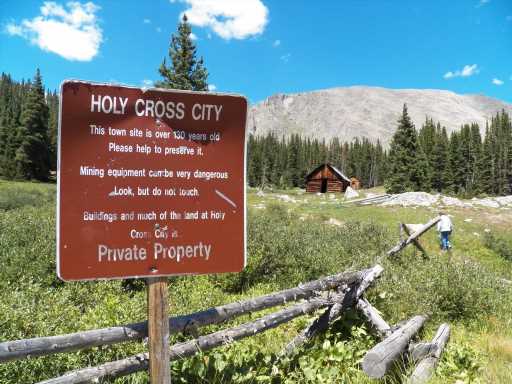
Holy Cross City
This town gets its name from nearby Mount of the Holy Cross. The town itself was once home to 300 people and had a post office and hotel, but it was abandoned by the 1890s. Semi-intact buildings and rusted boilers and other equipment remain. You can get there by driving the original road built in 1883, now known as Holy Cross Jeep Trail 759. Note that the U.S. Forest Service says it is one of the more difficult four-wheel-drive roads in Colorado due to rocks and boulders.
You can hike the road, 4 miles each way, to each the site. For a quieter experience hike from the Fancy Lakes Trailhead into the Holy Cross Wilderness and turn right at the sign for the ghost town, a round-trip distance of 7.5 miles. If time permits take a detour to Fancy Lake, a gorgeous alpine lake that makes a great stop for lunch or an overnight camp.

Independence
Independence Pass is one of the highest and prettiest paved roads in Colorado, connecting Aspen with the rest of the world to the east in the warmer months. The name comes from this town founded in 1879 high in the snowy tundra at about 11,000 feet. By 1882 the town had a population of 1,500, 40 businesses and three post offices. When the gold ran out most people fled this harsh climate.
A few hung on until 1899, when one of the worst snowstorms in Colorado history cut them off and they faced starvation. Homes were dismantled to make skis and residents fled Independence, never to return. The remaining buildings – eight largely intact – have been preserved by the Aspen Historical Society. Interpretive signs share the town’s history.
You can’t miss the ghost town while driving on Independence Pass; it’s right along the highway.

Mayflower Gulch
Pull out your hiking shoes. This hike, which starts off Fremont Pass between Leadville and Copper Mountain, leads into a stunning mountain cirque littered with mining remains. The trail follows the road built in the 1890s when miners created the Boston Mine. Some $500,000 in gold and silver were produced and a robust village formed. But before long it was abandoned as the ore was deemed to be impure.
It’s a popular hike, an easy 3 miles to the old town itself. You can continue on a fine trail higher into the basin to discover more mining buildings.

Red Mountain Pass
There are too many mines and ghost towns to name on this stunning mountain pass between the towns of Ouray and Silverton. They are built along perilous cliffs, with equipment spanning dizzying chasms. Most of the mining occurred between 1882 and 1893, and the towns and hamlets are victims of the same silver crash that closed so many mines.
You can see most of the buildings from the road, U.S. 550, but you may want to park and wander around the townsite of Ironton, where some residents clung on until the 1970s. The trails and preserved buildings are the result of work by the Red Mountain Task Force, which purchased 8,500 acres to preserve and installed interpretive signs that share the area’s history with visitors.

St. Elmo
It’s rare to find an open general store in a ghost town, but you will in St. Elmo near Mount Princeton, southwest of Buena Vista. In its heyday around 1890, some 2,000 people lived in the town. Many of them worked in roughly 150 mines dotting the hillsides. The railroad was extended below the Continental Divide into the Gunnison Valley, making the town an important railroad hub.
St. Elmo followed the typical trajectory of former mining towns: years of decline and then near desertion when the railroad stopped. Legend has it the last of St. Elmo’s full-time residents rode the last train out of town in 1926.
Tourism revived the area and many buildings were preserved. The St. Elmo General store is open throughout summer. Visitors can buy antiques, souvenirs and refreshments.
Passenger cars can easily reach the ghost town on County Road 162. Area roads get rougher after that, though sturdy four-wheel-drive vehicles can continue to Tincup Pass. There are hiking and mountain biking trails in the area.
Summitville
This town, built at 11,000 feet elevation, offers a different side of Colorado’s mining history. One of the earliest booms in the San Juan Mountains began here in 1876 in the rugged country south of the towns of Del Norte and South Fork. By 1890 there were as many as 1,500 residents and nine mills. Slow decline followed as the mills were shuttered and the post office closed in 1912.
It’s a long drive to reach this site, 30 miles up Park Creek Road from U.S. 160, but passenger cars can make it in dry weather.
Unlike other ghost towns, Summitville had a second act, and Colorado is still paying for it. A Canadian company established a pit mine here, but mismanaged it, spreading toxic chemicals to area watersheds. Today the area is a Superfund site and is known as one of the worst environmental disasters in the state’s history.
The mining buildings are well-preserved, but so is the modern water treatment station, which is full of brackish, toxic water that should serve as a reminder of the downside of the mining booms that helped build Colorado.
Source: Read Full Article